Blowin’ in the Wind - Communities at Risk from Fort Ord Burns
By Pat Elder
September 9, 2025
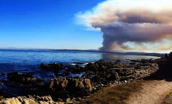
October, 2013 - Army fire seen from across Monterey Bay darkens the sky. KSBW
This fall, the Army plans to burn 400 acres in an area of the former Fort Ord they call Unit A, about a mile and a half southeast of the University Center of the California State University Monterey Bay. The inferno will likely take place in September or October when the Army believes there’s a better chance the prevailing winds will guide smoke away from the land and toward the sea.
The Army says the burn is essential for removing unexploded munitions. Past burns have blanketed communities and Monterey Bay with ash, while scientists warn that these fires can loft more than just smoke from the California chaparral and all the critters living there.
The Army’s indefensible plans risk mobilizing toxic residues from decades of military activity, including solvents, heavy metals, and other persistent pollutants embedded in soil. In the past, safety assurances failed to account for the complex mix of contaminants that were carried downwind into homes, schools, and workplaces. The next burn is perilously close to population centers.
Let’s look at the map below.

See the red dot. It shows the location of the University Center of the California State University Monterey Bay, just 1.5 miles northwest of the boundary of the soon-to-be-burned 350-acre Unit A.
The two areas immediately south of Unit A are identified as Unit C, containing 145 acres, and Unit B, containing 265 acres.
On Thursday, Oct 5, 2017 the combined acreage of Units C and B was burned. The afternoon smoke column rose high and drifted out over Monterey Bay. The plume was visible across the bay. Smoke lingered into the next day along much of the Monterey peninsula.
During the operation, Bill Collins, who served as the Environmental Coordinator for the Army’s Fort Ord Base Realignment and Closure Office, told local media, “The fire is doing exactly what we want it to.” This remark captured the Army's strategy for the burn. They want the smoke plume to be carried into the ocean, minimizing local exposure, and that’s their hope for the upcoming burn of Unit A.
The Army insists it chooses “optimum weather conditions,” yet coastal winds change by the hour, and the fire itself makes its own weather. In a single day, smoke can turn from a distant line on the horizon into a suffocating haze over homes, schools, and farms. The plumes may carry PAHs, dioxins, metals, perchlorate, white phosphorus, and PFAS. They poison the air, the water, the fish, and they poison us.
The chart below shows 6 toxins likely to become airborne as a result of the fire. The chemicals travel in the air, are deposited in the ocean, and wreak havoc on marine ecosystems.

These dangerous toxins present potential pathways to human ingestion. Offshore plumes shift the problem of the burn from immediate respiratory stress to long-term toxic legacy. This makes the health impact potentially greater in the long run, even if less visible in the short term. They are poisoning the planet!
When the winds don’t cooperate with the Army’s plans, the toxic plumes often sweep across Highway 68 and into the canyons and neighborhoods southeast of the burn, coating school desks in Spreckels with black ash and choking residents of Toro Park, Las Palmas, San Benancio, and Corral de Tierra. At other times, sudden wind shifts send smoke and ash across the Monterey Peninsula, into Marina and Seaside.

The red marker shows the center of the burn area this time.
Most frequently impacted areas
The Highway 68 corridor and adjacent canyons/neighborhoods southeast of the burn sites have historically been the most frequently impacted areas. These include Toro Park/Estates, Las Palmas, San Benancio, Corral de Tierra (incl. Serra Village, Toro Hills), Robley Road/Calera Canyon, and Spreckels.
Burn-season ocean-wind patterns often push smoke inland toward the south and southeast. The Army has noted “considerable” smoke near Highway 68 to the east/southeast of Fort Ord, and the Army repeatedly lists Toro Park and San Benancio as directly adjacent receptors.
Areas that are occasionally heavily impacted
To the southwest, the Monterey Peninsula communities of Monterey, Pacific Grove, Carmel (-by-the-Sea), Del Rey Oaks, Pebble Beach, Seaside, and Sand City have also been dangerously impacted during past burns. On some burn days, winds turned offshore or southerly, or burns escaped lines and pandemonium ensued. During the Oct 2003 event, residents of these towns furiously complained about smoke and ash. In Oct 2017, offshore winds pushed the plume over the bay and Monterey.
How bad will the Army’s expected burn be? Who will be most impacted?

Bob Dylan’s Blowin’ in the Wind lyrics
During 1997–1998 burns, residents in Marina, northwest of the burn, reported dense smoke and ashfall that forced schools to close and sent people with asthma and other respiratory conditions to emergency rooms. The burn in 2003 blanketed Marina in visible ash.

The University Center at CSUMB is a mile and a half from the planned burn.
During the Sept. 17, 1998 burn, a student, watching from her California State University Monterey Bay dorm room in Marina, observed the plume. Nineteen‑year‑old Stacie Halas stared in awe at the plume heading toward her dorm window. Another student described watching a “greenish-black plume” from her dorm window during a burn.
During the 2013 burn, the Monterey Bay Unified Air Pollution Control District logged multiple smoke complaints from Marina. Some reports noted smoke settling low over residential areas throughout the evening.
Even the residents of Salinas to the northeast reported thick black plumes drifting toward the valley. These plumes caused public alarm—visible even across Salinas Valley and prompting concerns about toxic exposure.
When the Army conducts prescribed burns at the former Fort Ord, it cannot predict the wind direction with pinpoint accuracy. Coastal winds change quickly, often shifting several times during the day, while valley winds can pull smoke inland. The hills, canyons, and the Salinas Valley “funnel” winds in unexpected ways. The morning land breezes, afternoon sea breezes, and evening drainage flows can flip the direction in a few minutes.
It is unsettling that fires make their own weather. Heat from the burn can pull in air, bend winds, and lift smoke differently than forecasts predict. You don’t need a weatherman to know which way the wind blows.

In a March 2025 factsheet, the Army conveys a sense of confidence in describing the upcoming burn.
“The Army uses local support from Naval Postgraduate School meteorologists who monitor weather conditions. When optimal weather is forecasted, the project meteorologist will analyze the data in greater detail and confer with meteorologists from the National Weather Service and California Air Resources Board. The Army will verify the availability of fire equipment and personnel. If the weather forecast continues to be favorable and resources are available, the Army fire department will mobilize burn equipment and personnel.
The Army fire department will start the prescribed burn only when optimum weather conditions are anticipated. Notifications will be sent when the burn has started and again when the burn is complete.”

Please visit the Fort Ord Contamination website and consider supporting our work. You’ll see where to contribute at the bottom of our homepage. Initially, we considered testing the air during the upcoming burn, but the cost of doing so is prohibitive. https://www.fortordcontamination.org/
The Army, the state of California, and the EPA emphasize their confidence in safety protocols, modeling, and outreach, but they’re downplaying the risks. They tend to focus on compliance with weak regulatory thresholds and the need to clear unexploded ordnance, rather than on the long-term cumulative health effects from smoke laced with toxics.
They are missing the mark. “Avoid smoke if you are sensitive,” “Close your windows,” and “We’re monitoring air quality,” are a far cry from naming carcinogens that ride the plume. They are failing us.
The Army’s communications are all about maintaining confidence and avoiding panic than about grappling with uncertainty. This is where distrust in the community grows., and that distrust would be amplified if the local press reported on the threat to human health.
ChatGPT 5: Describe local press coverage of the health impacts of the prescribed burns at Fort Ord. Have they reported on the specific toxins or carcinogens in the smoke?

“Thought to be released” ought to be “known to be released.” The dreaded advocacy-driven reporting! Military Poisons is an advocate for pregnant mothers and their babies, especially during the first trimester of pregnancy. It just doesn’t fit into the mainstream narrative.
Environmentalists argue that these burns harm the environment and human health. They say the Army should fence off the area, leave it alone, and let it grow. Build new communities elsewhere.
There’s a philosophical divide here. The Army’s stance is about returning land to productive use, like bombing it or building on it. The country must have this conversation. Live-fire exercises are deeply embedded in the training infrastructure at more than a thousand active U.S. Army sites across the country. The same toxins are being spread around and people are getting sick.
Some landscapes have been too heavily altered so the most responsible act is restraint.