
California Forever’s PFAS Blindspot
Pat Elder
October 8, 2026

Carcinogenic aqueous film forming foam (AFFF) falls like snow at Travis Air Force Base - U.S. Air Force photo - Sept. 24, 2013.
Introduction
A conspicuous blind spot runs through the public discussion of the California Forever/Suisun Expansion project. The developer has acquired roughly 55,000 acres adjoining Travis Air Force Base on three sides [1]. At the same time, Air Force PFAS investigations have documented dangerous levels of contamination in groundwater, soil, surface water, sediment, pore water, stormwater infrastructure, and treatment-system influent within the installation [4,12].

Rep. John Garamendi, (D-CA-08)
Congressman John Garamendi (D-CA-08) embodies the very paradox of this local information gap. In Washington, he has consistently voted to pass aggressive national PFAS remediation legislation. In Solano County, he has been one of the most vociferous opponents of the California Forever megacity. Yet, despite holding these parallel positions, Garamendi represents the precise blind spot of this crisis: he has never publicly connected his federal fight against military "forever chemicals" to his local fight against the development, ignoring the reality that the base's expanding toxic plumes are migrating into the aquifer designated for the new city's future residents.
These two realities have not been joined in the public record. California Forever’s project materials and development reports do not address PFAS. Published accounts by Bay Nature and Solano Together, likewise, do not connect documented releases of dangerous levels of PFAS to the project’s proposed groundwater wellfields and surface-water supplies. Suisun City and the Suisun-Solano Water Authority have not published an assessment of whether PFAS associated with Travis could affect those proposed sources. [2, 3, 30]
The public has been left unaware of the serious PFAS question hanging over the California Forever/Suisun Expansion project. Even the limited information now available is scattered among difficult to find, highly technical military reports and restricted well-location records. The result is a profound information gap: the public cannot evaluate whether water proposed for a new city could be vulnerable to contamination associated with Travis Air Force Base.
Groundwater in the alluvial aquifer beneath Travis is reported to move generally southward, with flow toward the southeast and southwest; the southeast component flows toward the area proposed for the new city. The housing/commercial area is not proposed immediately against the base fence. The plan places a 5,726-acre Travis Protection Zone south and southeast of the base, retaining very restrictive agricultural/open-space-style land uses. The actual new community’s 15,737-acre Specific Plan lies farther east and south. The entire annexation is 22,873 acres [30].
Off-base contamination is documented
In June 2020, the Air Force sampled six private drinking-water wells south of Travis Air Force Base and found that three exceeded the then-current EPA lifetime health advisory of 70 ppt for PFOS and PFOA. The Air Force described its off-base drinking-water treatment effort as operating within a four-mile radius of Travis Air Force Base. [31] This radius would extend outside of the Travis Protection Zone, into the California Forever/Suisun megacity.
By late June 2021, the Air Force had installed ion-exchange treatment units at the properties. The San Francisco Bay Regional Water Quality Control Board said the systems would be tested at startup, after one and three months, and then quarterly. [32]
In June 2022, the Air Force reported non-detect results for PFOS, PFOA, and PFBS in the treated effluent from all three systems; it reported the same result after quarterly sampling in January 2023. The public materials do not disclose the original well concentrations or identify the households. [33]
There is no public confirmation that the systems are still being serviced in 2026.
In January 2023, the Air Force acknowledged that 25 planned off-base monitoring wells at 13 locations had not been installed. The stated reasons were unresolved access and an internal problem obtaining the base commander’s signature for permits. The proposed wells were to be placed on county or city land, not private property. Air Force personnel said AFCEC was working to shift permit-signature authority from the base commander to AFCEC to overcome the delay. [33]
The record does not show that the base commander possessed independent legal authority to veto an off-base PFAS investigation. Rather, it likely demonstrates that the Air Force had made command-level approval an internal administrative requirement. Section 106 of the National Historic Preservation Act requires the responsible federal agency to consider effects on historic properties before undertaking work; it does not give a base commander unilateral authority to cancel a CERCLA investigation.
There is no later public record confirming that the specific 25 wells were installed. In September 2026, the Army Corps of Engineers awarded a $9.523 million Travis PFAS Remedial Investigation Data Gaps Phase 1A contract to obtain the additional soil, groundwater, sediment, and surface-water information necessary to understand the contamination’s vertical and lateral extent. That’s all we know. This likely indicates that the off-base delineation gap identified in 2023 was still unresolved. [34]
The public has not been provided a clear accounting of the sampling locations, results, and their relationship to California Forever’s landholdings or proposed water sources. Meanwhile, California Forever proposes substantial reliance on local groundwater and surface-water diversions.
Before land-use approvals or drinking-water infrastructure proceed, the developer and responsible agencies should disclose the locations, depths, and screened intervals of proposed production wells; the exact locations of proposed surface-water intakes; all available Travis off-base PFAS sampling results; and full PFAS analytical results for every prospective source.
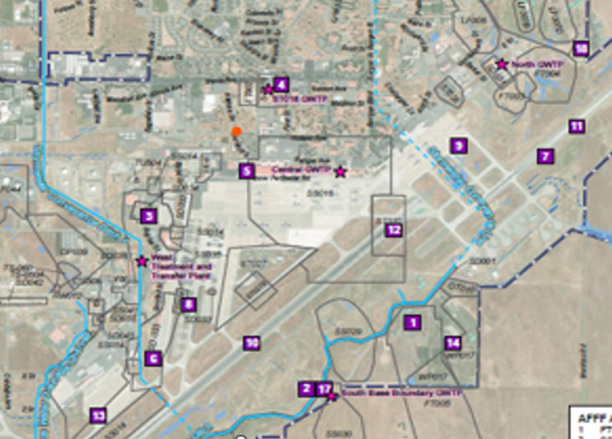
Figure 1-2, Travis Air Force Base - Site Map Phase I Remedial Investigation, 2026
The numbers represent 16 areas where aqueous film-forming foam (AFFF) was used and discarded on base. The southeastern boundary with the California Forever/Suisun Expansion project is shown toward the bottom right.
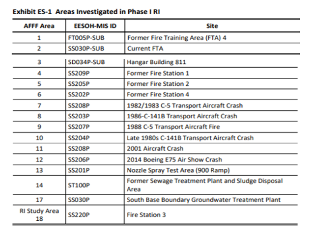
These locations identify where high concentrations of PFAS are found in the environment as a result of the use of toxic firefighting foams. Exhibit ES-1, Phase I Remedial Investigation, 2026
Analytical results generated during the Phase I Remedial Investigation confirm the heavy presence of PFAS in soil, groundwater, surface water, sediment, and pore water in locations throughout the base. PFAS were identified at every AFFF area investigated.
California Forever’s Water Plan and the Missing PFAS Analysis
Suisun City is served by the Suisun-Solano Water Authority (SSWA). Its water is Lake Berryessa surface water conveyed through the Putah South Canal and treated at Cement Hill—not Travis groundwater. SSWA completed required PFAS monitoring in 2024. PFAS compounds were not detected in the Authority’s water supply. That result describes SSWA’s existing treated drinking-water supply; it does not answer whether California Forever’s separately proposed groundwater or surface-water sources contain PFAS [5].
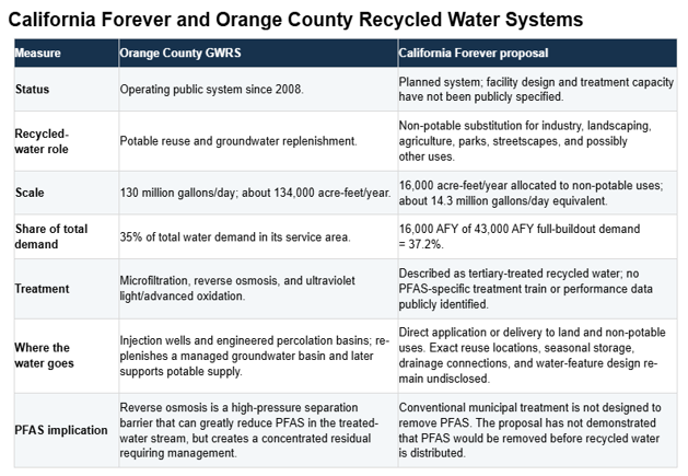
California Forever and Orange County Recycled Water Systems - Military Poisons [35]
Both systems assign roughly one-third of total water demand to recycled water. The technical systems, end uses, and unresolved environmental questions are very different.
California Forever’s current proposal says total demand at buildout would be 43,000 acre-feet per year. It proposes to meet 16,000 acre-feet of industrial, landscaping, and other non-potable uses with recycled wastewater, leaving 27,000 acre-feet per year of net supply demand [6].
California Forever says it has assembled 29,280 acre-feet per year from a portfolio that includes existing surface-water and groundwater uses on its own properties as well as supplies from outside Solano County. The company has not publicly broken out how much of the 29,280 acre-feet comes from each source category, or identified the proposed wellfields, aquifers, screened intervals, and PFAS results [6, 8].
Its published plan includes groundwater as a major proposed supply category, yet it has not publicly identified the proposed well locations, screened aquifer intervals, pumping volumes by wellfield, or comprehensive PFAS results for those sources. Because the Travis PFAS investigation has not fully delineated groundwater contamination off base, California Forever has not shown whether any proposed groundwater supply is hydraulically separate from, or potentially affected by, the broader Travis contamination problem [4, 6].
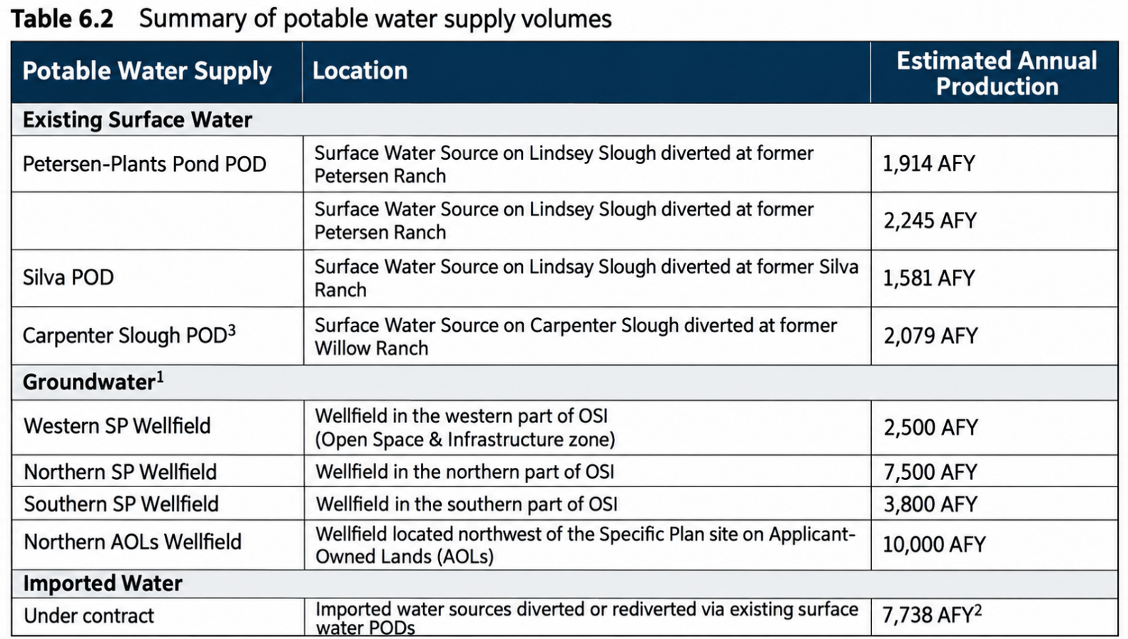
California Forever’s Proposed Water Portfolio
The only surface-water results reported in either the 2018 Site Inspection or the 2026 Phase I Remedial Investigation are from Union Creek.
Lindsey Slough and Carpenter Slough connect to the larger Barker Slough–Cache Slough complex, a network of Delta waterways subject to various water-quality monitoring programs. Those programs do not necessarily include PFAS, however, and monitoring elsewhere in the Delta cannot establish PFAS concentrations in these particular sloughs [2].
The Western, Northern, and Southern SP Wellfields and the Northern AOLs Wellfield are identified as proposed groundwater-supply sources in California Forever’s table. Publicly available materials do not identify the aquifer units, screened intervals, or capture areas for those wellfields [6, 7].
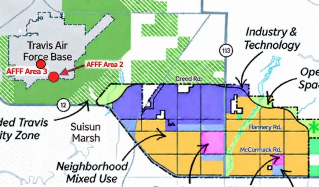
The Travis Security Zone was established outside the New Community by creating a Travis Reserve Area of 14,900 acres.
Map color Description
Dark green. Protected Travis Compatibility Zone
Green with hatching Protected agriculture and open space / conservation land
Black outline Proposed development-plan boundary
White / gray area Travis Air Force Base
Orange / purple / pink Proposed urban land-use districts
The Travis Protection Zone shown on the project maps separates the proposed new community from Travis Air Force Base through restrictive agricultural, open-space, and compatibility land uses. That buffer may reduce direct land-use conflict with the base, but it does not answer the separate groundwater question: where the proposed production wells would be located, which aquifer intervals they would draw from, whether pumping could alter local groundwater gradients, and whether the wells would be protected from PFAS contamination [9].
Reports by the Air Force show that plumes containing PFAS, total petroleum hydrocarbons (TPH), volatile organic compounds (VOCs), and trichloroethylene (TCE) have historically contaminated the groundwater tables underneath and down-gradient from the base. Air Force investigations have documented legacy petroleum hydrocarbons, volatile organic compounds, and a host of contaminants in groundwater at Travis. See the Addendum at the end of this report [31].
Continuing sources and migration pathways
The Travis AFB Remedial Investigation concludes that groundwater and surface water are the principal routes by which PFAS leave the base. Once PFAS enter the subsurface, they can move downward into groundwater and then interact with streams, drainage channels, ephemeral wetlands, and vernal water features [4].
PFAS migration between groundwater and surface water also appears to be an important pathway across much of Travis AFB, particularly along the stormwater and surface-water drainage system and where ephemeral or vernal surface-water features occur. This is especially important at Travis because the stormwater and surface-water drainage system receives virtually all base runoff, as well as effluent from groundwater-treatment systems [4].
A groundwater-flow rate as high as 200 feet per year demonstrates the potential for contaminants to migrate substantial distances over time, potentially reaching the proposed development area. That question can be answered only through off-base monitoring wells and complete horizontal and vertical delineation [2].
What the Air Force investigated and what it left out
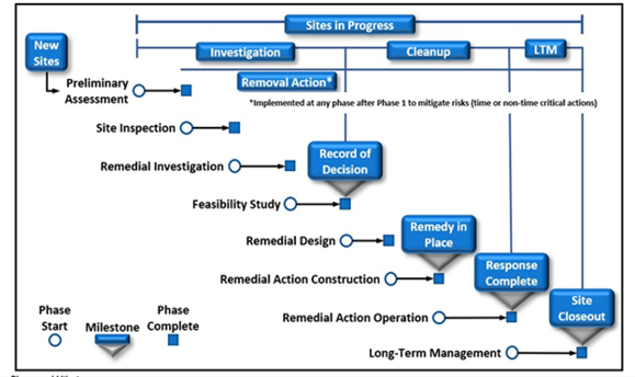
The Comprehensive Environmental Response, Compensation, and Liability Act (CERCLA), enacted by Congress in 1980 and commonly known as the Superfund law, provides the framework for the Air Force investigation [7].
The Air Force performed Travis PFAS work adhering to the (CERCLA) process, beginning with a Preliminary Assessment intended to identify locations where there was a reasonable expectation of a PFAS release from Air Force activities. The CERCLA process operates at a snail’s pace and has not resulted in measures to actually “clean up” the contamination at Travis or anywhere else [11].
At Travis, the first three steps of the process: the Preliminary Assessment, Site Inspection, and the Remedial Investigation have focused on releases only associated with AFFF use, handling, storage, fire training, fire stations, hangars, and emergency responses. The record does not reflect an evaluation of other potential PFAS-use areas [4, 11, 12].
Potential non-AFFF PFAS uses and notable areas on military installations include:
· Chromium-electroplating fume suppressants, historically including PFOS-based products.
· Wastewater evaporation ponds and sludge drying beds.
· Aircraft and vehicle hydraulic fluids, lubricants, and greases containing fluorinated additives.
· PTFE and other fluoropolymer wire and cable insulation.
· Coatings on aircraft parts, vehicles, equipment, and piping.
· Water-, oil-, and stain-resistant uniforms, tents, upholstery, carpets, and protective gear.
· PFAS-containing sealants, gaskets, O-rings, tapes, and tubing used in maintenance shops.
· Landfills where these PFAS-laden products are discarded.
The 2017–18 Site Inspection selected 16 AFFF areas for sampling. The resulting January 2026 Phase I Remedial Investigation follows that same AFFF-centered chain of site selection [4, 12].
That process did not establish that other PFAS uses at Travis were absent or harmless. Some known or plausible AFFF-related areas were not sampled during the Site Inspection. For instance, Fire Station 5 and the 1993 C-141B fire were left out of the analysis [2, 4].
CERCLA’s reach is not limited to AFFF-release sites. It authorizes investigation and response to actual or threatened releases of PFAS from any relevant source or disposal pathway, including landfills, buried waste, drums, waste-storage areas, contaminated soil, stormwater infrastructure, and former industrial operations. The Travis RI itself identifies several such plausible pathways, yet it reports no PFAS sampling at these sites [4].
The programmatic delays identified in the 2023 administrative timeline remain actively unresolved. In September 2026, the U.S. Army Corps of Engineers awarded a new $9.523 million 'Travis PFAS Remedial Investigation Data Gaps Phase 1A' contract to General Mechanical Corporation. This late-2026 contract confirms that critical vertical and lateral boundary delineations for off-base groundwater, sediment, and surface-water contamination are still fundamentally missing from the public record, [34] leaving the true reach of the toxic plume beneath prospective development lands unquantified.
How contamination moves: soil, pore water, groundwater, and surface water.
SOIL
The Air Force’s 2018 Final Site Inspection documented extensive PFAS contamination in shallow soil around Fire Station 2 at Travis AFB [12].
At just 0.5 feet below ground surface, one sample contained 2,100,000 ppt of PFOS, while another surface sample contained 170,000 ppt of PFOA and 550,000 ppt of PFOS. These results identify the Fire Station 2 area as a severely contaminated source area requiring further delineation of PFAS in soil, groundwater, runoff, and exposure pathways. Fire Station 2 is also known as AFFF Area 5, one of 16 AFFF areas on base [12].
Following are the results from the testing in 2018 in micrograms per kilogram, (ug/kg), or parts per billion.
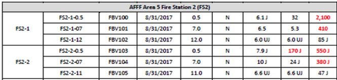
Final Site Inspection for AFFF Areas at Travis Air Force Base, California
Surface Soil at Fire Station 2 (0.5 ft)
Highest concentration for PFOS 2,100,000 ppt
Highest concentration for PFOA 170,000 ppt
Highest concentration for PFBS 10,000 ppt
Pore Water
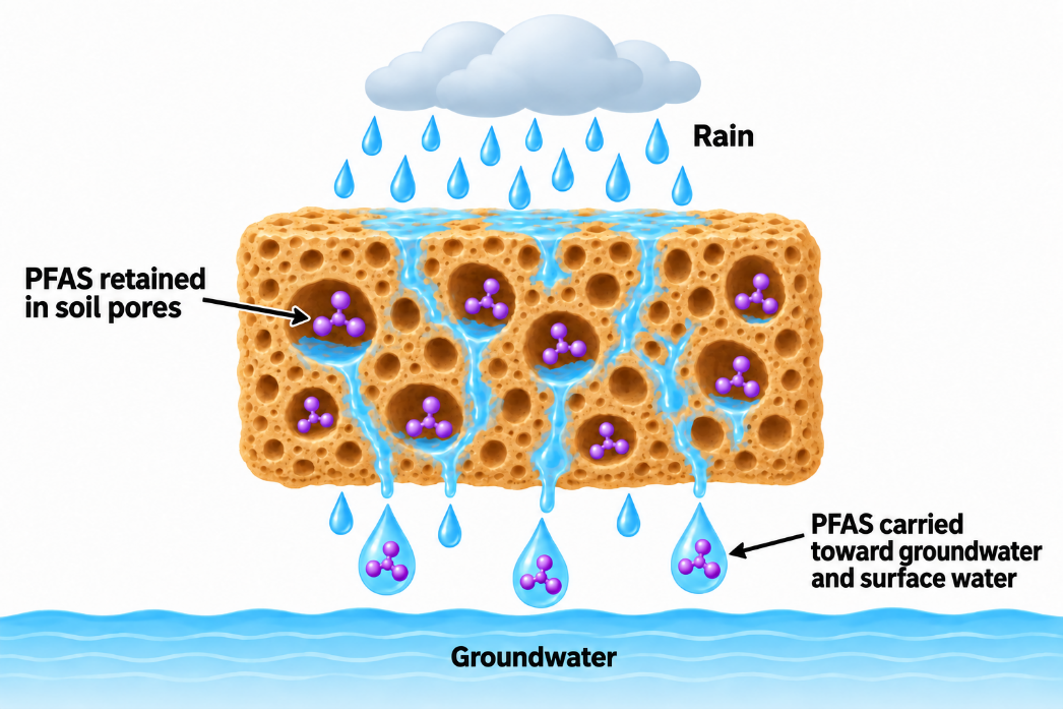
Pore water is the water held in, and moving through, the spaces between soil particles above the groundwater table.
We must understand the dynamics of pore water to comprehend how the PFAS that have been spewed upon the soil throughout the base over the last 50 years act upon the groundwater and the surface water today.
Twenty-seven pore-water samples were collected and analyzed during the Phase I Remedial Investigation. Investigators installed eight lysimeters—devices designed to collect water from unsaturated soil in AFFF Area 5 and AFFF Area 6. The lysimeters were sampled quarterly for one year [4].
Above the groundwater table, some pore spaces contain water while others contain air. As rain and other water infiltrate the ground, pore water can mobilize PFAS from contaminated soil and carry them downward toward groundwater or laterally toward surface-water drainage systems.
The lysimeter results are liquid measurements, reported in nanograms per liter. In water, 1 ng/L is equivalent to 1 part per trillion. These results do not measure the total quantity of PFAS retained in the surrounding soil [4].
PFAS concentrations in pore water greatly exceeded the Air Force’s Project Screening Levels:
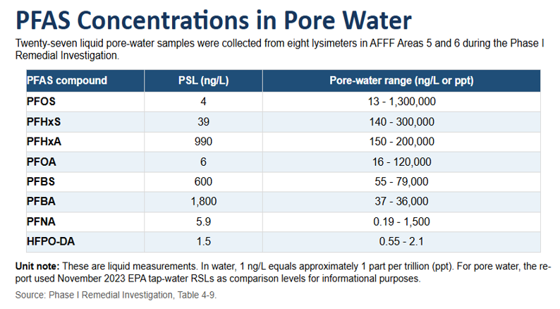
Project Screening Levels (PSL’s) are used to decide whether a detected chemical level warrants further investigation.
The maximum concentrations—1,300,000 ppt of PFOS, 300,000 ppt of PFHxS and 120,000 ppt of PFOA—show that extraordinarily contaminated water was present within the soil profile during the monitoring period. This was not groundwater sampled from a monitoring well. It was water collected while still within the unsaturated soil above the groundwater table [4, 12].
At AFFF Area 5, groundwater was encountered approximately 10 to 12 feet below ground surface during lysimeter installation. The pore-water findings therefore provide direct evidence that PFAS were available for transport through the soil above that groundwater. Other AFFF areas at Travis had substantially higher groundwater PFAS concentrations, but the lysimeter investigation was limited to Areas 5 and 6 [4].
Taken together, the soil and pore-water results indicate that contaminated soil remains an ongoing source of PFAS to groundwater at multiple locations.
The investigators cautioned that the available data was not sufficient to quantify this process fully. Additional sampling is needed to characterize the complexity of the contaminated subsurface and to determine site-specific dilution and attenuation factors [4].
The pore-water results demonstrate a frightening and active PFAS migration pathway and should sound an alarm for any proposed development nearby. PFAS groundwater plumes (especially PFOS) at many contaminated sites have likely extended for miles [22], but investigators have not yet determined exactly how far the Travis plumes extend beyond their known boundaries, although well testing within a 4-mile radius shows PFAS contamination.
Groundwater
The January 2026 Phase I Remedial Investigation presents a troubling picture of PFAS moving through groundwater at Travis Air Force Base. Groundwater flow is generally to the south, southwest, and southeast at an estimated rate of 100 to 200 feet per year [4].
PFAS are present beneath a large portion of Travis AFB and appear to form large, commingled plumes originating from multiple source areas. The full off-base extent of the contamination remains undetermined [4].
Across the military’s PFAS program, off-base delineation is usually incomplete. Travis is part of a wider pattern in which groundwater contamination has been identified, while its full lateral and vertical extent, and its relationship to nearby wells, streams, and communities, remain unresolved.
The Remedial Investigation calls for additional off-base sampling, particularly to the southwest and southeast [4].
The Air Force report says additional sampling is required “to achieve full horizontal and vertical delineation of PFAS impacts in environmental media at Travis AFB.” It also states, “Vertical delineation is incomplete at many AFFF areas.” This means the Air Force has not yet determined how deeply PFAS contamination extends beneath the ground.
These Phase I findings fail to establish the full boundaries of the problem. They establish that persistent PFAS contamination is present in groundwater at extreme multiples of screening levels, that groundwater generally moves southward, and that pathways leading off base remain incompletely mapped [4].
More than half a century after PFAS manufacturers’ own research identified serious toxicity concerns, the Air Force still does not know where contamination at Travis has traveled, how deeply it extends, and exactly how far it has moved beyond the base’s boundaries.
Before we analyze specific concentrations reported in the current 2026 Remedial Investigation, we should be familiar with the highest groundwater results reported during the 2018 Final Site Inspection for AFFF Areas at Travis Air Force Base. The results for groundwater fire Station 2 appear below.
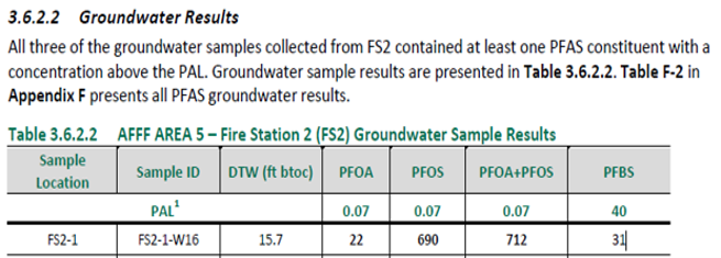
From the 1018 Site Inspection. Concentrations are recorded in ug/L or parts per billion.
The Air Force reported on three compounds: PFOA, PFOS, and PFBS. [12].
=========================
Now, let us shift our attention to the current Remedial Investigation.
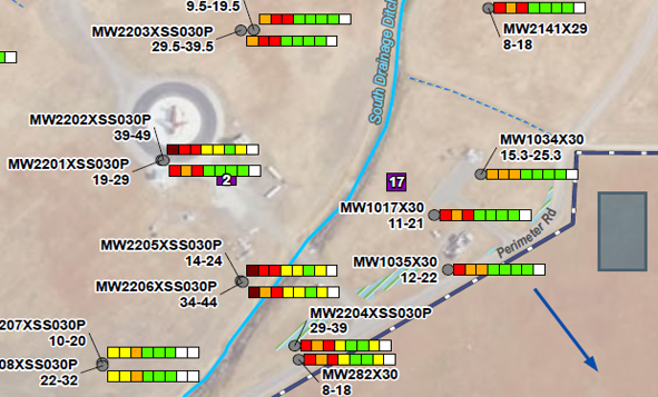
This is a snapshot of heavily contaminated areas close to the southeastern border of the base. The colored boxes show dangerous levels of contamination. The circular area with the aircraft is one of the fire training areas on base. The blue arrow shows the direction of groundwater flow. It is pointing southeast, toward the planned California Forever Project.
To understand what the color-coded map represents, we can examine monitoring well MW2201XSD034P14-24, located just south of AFFF Area 2.
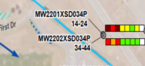
Monitoring Well MW2202XSD034P14-24. This well tested water from 14 feet to 24 feet below the surface. The blue arrow shows the direction of groundwater heading in a southeastern direction [4].
RI-PSLs are Remedial Investigation Project Screening Levels, (RI-PSL’s). They are concentration values used to determine whether a detected chemical warrants further investigation. Every location shown above with an exceedance warrants further investigation [4].
Understanding the color scheme for the wells
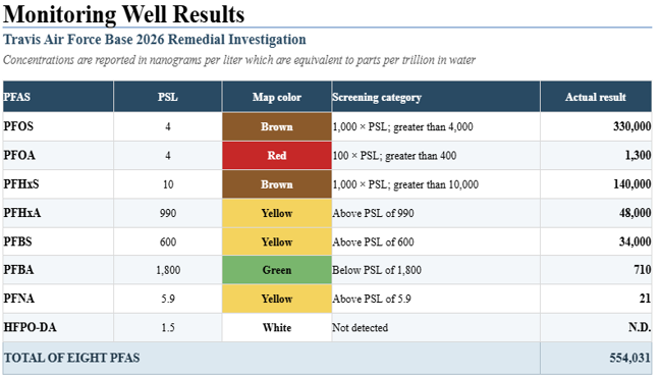
Adapted from Table 4-3, Groundwater Analytical Results, Phase I Remedial Investigation of Aqueous Film-Forming Foam Areas at Travis Air Force Base, January 2026.
The broad color categories obscure the enormous differences between the screening levels and the actual concentrations. For instance, PFOS at 330,000 ppt is 82,500 times the 4-ppt Project Screening Level – not just 1,000 times the PSL!
PFOA at 1,300 ppt is 325 times the 4-ppt PSL. while PFHxS at 140,000 ppt is 14,000 times the 10-ppt PSL.
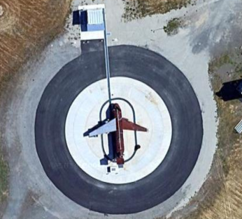
The Current Fire Training Area (AFFF Area 2) is located northwest of Union Creek and Perimeter Road on the southern boundary of the base, adjacent to Forever California property. Fire training exercises using an old aircraft engine fuselage in a pit were conducted from 1987 to 1996. The current FTA was built in 1996 and contains a mock aircraft placed within a circular concrete enclosure [4].
PFOS, PFOA, PFHxS, PFHxA, PFBS, and PFNA were found in groundwater, all above their respective inflated Project Screening Levels. PFOS was as high as 12,000 ppt, heading southeasterly, in the direction of the new city [4].
Groundwater treatment plants
Travis AFB operates groundwater-treatment plants to address legacy contaminants, but the January 2026 Remedial Investigation states that further evaluation is needed to determine “if and how the operational GWTPs at Travis AFB may reduce PFAS concentrations.”
Given the longstanding operation of these systems and the age of the known PFAS releases, the absence of a complete public accounting of PFAS entering and leaving the treatment plants is difficult to justify.
The 2018 Site Inspection says the South Base Boundary Groundwater Treatment Plant collects groundwater from as many as 34 wells across the base. It uses two bag filters followed by two 6,000-pound granular activated-carbon vessels, then discharges the treated water to Union Creek. The plant was built to address legacy volatile organic compounds and fuel contamination, not specifically PFAS [12].
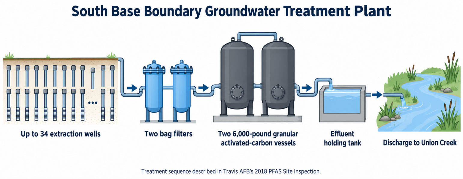
The South Base Boundary groundwater-treatment plant was built to address legacy VOC and fuel contamination, not specifically PFAS.
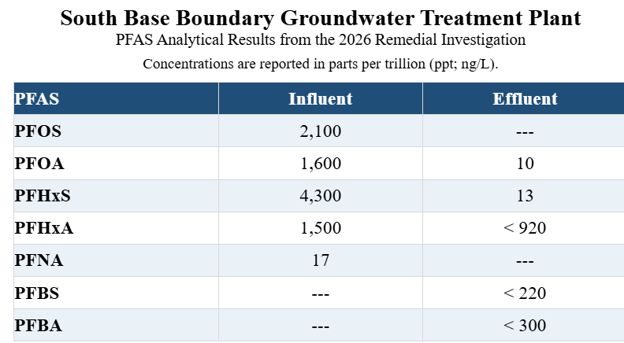
Note: “---” indicates a result not reported in the available table. “<” indicates a result reported below the laboratory reporting limit.
The laboratory reporting limits severely weaken the effluent data. The reported “<920 ppt” for PFHxA does not establish that the compound was removed or absent; it merely shows that the laboratory could not quantify it below a reporting limit set at 920 ppt, almost equal to the Air Force’s 990-ppt groundwater screening level. Similarly, “<220 ppt” PFBS and “<300 ppt” PFBA are censored results, not zeroes [4].
If that stated limit applies to PFHxA, PFBS, and PFBA individually, the laboratory reporting limits used for Travis effluent, 920, 220, and 300 ppt, were hundreds of times less sensitive.
This is not a transparent accounting of what the groundwater-treatment plant is releasing to Union Creek! It is a limited snapshot that confirms detectable PFOA and PFHxS in the effluent while leaving PFOS unreported and allowing several other compounds to disappear behind reporting limits too high to determine the levels of contamination entering the creek. It is painfully ironic that an $85 test kit could return results for 55 compounds in two weeks.
Cyclopure PFAS test kits measure 55 PFAS compounds at a 1-ppt limit of quantification using the EPA Method 1633 [26]. Cyclopure typically returns results within two weeks for a small fraction of the cost incurred by the Air Force. Travis records show that final public reporting can substantially lag field sampling.
The 2018 Site Inspection reported sampling was completed in August of 2017, while the Air Force only made the results public in April of 2019. While much of the Phase I Remedial Investigation fieldwork occurred in 2023, the final report was not issued until January of 2026 [4].
As we have seen, the 2026 Travis PFAS Remedial Investigation failed to provide results for PFOS effluent draining into Union Creek. The creek flows generally south and west into Suisun Marsh. From there, water enters Suisun Bay, part of the San Francisco Estuary [4].
Now, let’s examine the sole table on the South Base Groundwater Treatment Plant from the Site Inspection for AFFF, July 2018.
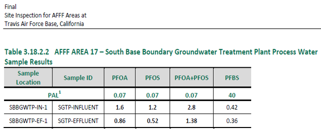
The Air Force reported results for three compounds: PFOA, PFOS, and PFBS.
The published numbers are in parts per billion, so they must be multiplied by 1,000 to express them as parts per trillion.
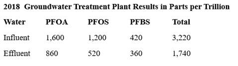
The United States has no PFAS standard for surface water comparable to a drinking-water maximum contaminant level. The European Union has adopted an annual-average environmental quality standard for PFOS in inland surface water of 0.65 ppt, so the concentrations draining into Union Creek are 800 times over that limit [12, 19].
The 2018 results demonstrate that PFAS entered the treatment plant and remained in the discharge to Union Creek. The reported PFOS effluent concentration of 520 ppt is especially concerning because PFOS aggressively bioaccumulates in fish at levels up to 4,000 times the levels in the water, according to the EPA [12].
PFAS migration between groundwater and surface water serves as an important migration pathway across much of Travis AFB, particularly along the stormwater/surface water drainage system and at locations where ephemeral or vernal surface water features occur.
Contaminated Fish
A Striped Bass from Suisun Bay contained 6,630 ppt of PFOS, according to the Regional Monitoring Program for Water Quality in San Francisco Bay, 2014. That may be compared to the maximum contaminant level of 4 ppt in drinking water. Although this is a potentially serious health issue, there is no additional data to report on PFAS concentrations in fish in Suisun Marsh or Suisun Bay [13].
The available fish data cannot assign the Suisun Bay contamination to Travis AFB. They do establish, however, that PFAS has entered the regional food web while the principal surface-water pathway from contaminated Union Creek draining from Travis AFB has not been matched with the off-base water, sediment, and fish monitoring needed to rule the base in or out [13].
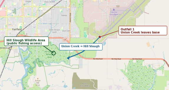
The nearest publicly identified fishing area downstream of Travis AFB’s Union Creek discharge is Hill Slough Wildlife Area. Union Creek flows approximately 1.1 miles from the base to Hill Slough, a branch of Suisun Marsh [10].
Surface Water
Travis’s stormwater and surface-water drainage system is central to understanding surface water PFAS migration. Union Creek receives virtually all stormwater runoff from the Base, along with effluent from groundwater-treatment systems. As we have read, the creek flows generally south and west into Suisun Marsh. From there, water enters Suisun Bay, part of the San Francisco Estuary [4].
Union Creek divides into two branches north of Travis AFB. The main eastern branch passes through Duck Pond, then enters a storm sewer beneath the runway before emerging in the southeastern part of the Base as an open channel. The western branch enters the northwestern part of the Base in an excavated channel and carries drainage from the western industrial area before joining Union Creek at Outfall II. On-base drainage has been extensively altered by creek rerouting, storm sewers, ditches, and development, but runoff ultimately enters Union Creek.
The January 2026 Phase I RI reported just one PFAS sample from surface water, shown below. That was from the South Drainage Ditch/Outfall #2 area. The report does not publicly provide a comparable, location-by-location account of concentrations elsewhere in Union Creek or the Base drainage network [4].
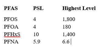
Reported surface-water concentrations — South Drainage Ditch / Outfall #2 June, 2022 (Dry Season)
In parts per trillion
Reported surface-water concentrations — South Drainage Ditch / Outfall
1,800 ppt of PFOS draining into Union Creek is an ecological disaster.
What remains outside the investigation
Landfills and Corrective Action Management Units (CAMUs)
Unlike the 2018 Site Inspection, the 2026 Phase I Remedial Investigation identifies Travis AFB’s former landfills and Corrective Action Management Unit (CAMU) as potential additional PFAS source areas. North and northwest of Fire Station 3 are LF006, a former burn-and-fill landfill, and LF007, a 94-acre trench-and-cover landfill that received general refuse, industrial wastes, and fuel sludges. LF007 also contains a CAMU into which contaminated soils from several other Travis sites—including former fire-training areas—were placed. The report states that unexplained PFAS exceedances upgradient of Fire Station 3 may reflect contributions from the landfills, CAMU, waste-disposal areas, stormwater infrastructure, or other sources, rather than Fire Station 3 alone [4].
The discussion is particularly significant because records describe a nearby hazardous-waste treatment, storage, and disposal facility that held forty 55-gallon drums of expired high-expansion firefighting foam—material that may have contained PFAS. The landfill and CAMU histories also include industrial wastes, fuel sludges, and soils transferred from former fire-training areas. Those histories establish plausible PFAS source pathways and warrant direct investigation; they do not, by themselves, establish the concentrations in the disposed material or prove a release. [4, 11].
No PFAS sampling results for LF006, LF007, the CAMU, or associated landfill areas are reported in the Preliminary Assessment, the 2018 Site Inspection, or the Phase I RI. The available record therefore does not establish whether PFAS have migrated from these areas, whether wastes placed there remain a continuing source, or whether they contribute to the unexplained upgradient groundwater results near Fire Station 3 [4, 11, 12].
Air & Dust
The 2018 Travis AFFF Site Inspection identified a potential PFAS air-migration pathway, but it did not document PFAS in air. The report explained that PFAS-contaminated surface soil could become airborne as fugitive dust and noted that nearly all soil screening-level exceedances occurred at surface locations. Yet the Air Force collected no air or fugitive-dust samples [12].
This is how the current Remedial Investigation treats the Air/Dust pathway to human ingestion:
“Hypothetical future residents (on-base), maintenance workers, and construction workers may potentially be exposed to PFAS-impacted surface soil (0.0 to 0.5 ft below ground surface) via inhalation, ingestion, dermal contact, and/or plant uptake (garden produce). Dust inhalation during activities such as digging, mowing, raking, or other minor soil disturbances, and incidental dermal exposure are considered potentially complete exposure pathways for hypothetical future residents and non-intrusive maintenance workers. These exposure routes are considered complete for intrusive construction workers. Ingestion due to plant uptake is considered potentially complete for hypothetical future residents and incomplete for maintenance and construction workers.”
The Air Force recognizes the potential dangers associated with the Air/Dust pathway but fails to investigate it any further.
A CDC/ATSDR environmental assessment near Shepherd Field Air National Guard Base in Martinsburg, West Virginia, shows why the PFAS investigation at Travis Air Force base and the lands encompassing the California Forever project must include an examination of dust and air.
In 2019, ATSDR collected tap-water and household-dust samples from 19 randomly selected participating homes while also testing residents’ blood. The dust results included very high individual concentrations of PFHxS (16,400 ng/g, or 16.4 million ppt), PFOS (13,900 ng/g, or 13.9 million ppt), PFOA (3.43 million ppt), and MeFOSAA (3.81 million ppt) [36].
The ATSDR reported that the community’s overall dust concentrations were similar to those in several comparison studies.
The wind carries tiny PFAS-contaminated dust particles that settle in our lungs and in our homes, impacting small children. For young children, hand-to-mouth behavior and incidental dust ingestion make household dust an important PFAS exposure pathway. Dust results demonstrate that a groundwater-centered PFAS investigation leaves a major exposure pathway unmeasured [12].

PFHxS and PFOS were the dominant high-end dust findings, reaching 16,400,000 ppt and 13,900,000 ppt, respectively in people’s living rooms. PFOA and MeFOSAA also reached multi-million-ppt concentrations. These results show that household dust can be an important pathway for children.
Travis AFB is almost 20 times larger than Shepherd Field. It operates at least five times as many aircraft as Shepherd Field, and it has an overall population that is 20 times greater than Shepherd Field ANG. We won’t know how this may factor into the potential hazard at Travis until a robust testing regime is pursued.
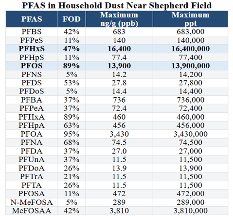
Table 11
Summary Statistics for dust samples collected in Berkeley County, West Virginia, adjacent to the Shepherd Field Air National Guard Base.
ATSDR reported maximum detected concentrations in dust. FOD is frequency of Detection.
Volatile PFAS

Fluorotelomer alcohols (FTOHs), including 4:2, 6:2, 8:2, and 10:2 FTOH, should be investigated at Travis Air Force Base. These volatile PFAS are associated with fluorotelomer-based chemistry often used in newer firefighting foams and in water- and stain-resistant treatments applied to textiles, including firefighter turnout gear and other military fabrics [27]. Heat, sunlight, abrasion, laundering, storage, and use can release volatile FTOHs from treated materials into indoor and outdoor air. They may also be present in foam residues, contaminated soil, dust, and groundwater near areas where fluorotelomer-based AFFF was handled or discharged.
Neither the 2018 Site Inspection nor the 2026 Phase I Remedial Investigation reports results for 4:2, 6:2, 8:2, or 10:2 FTOH. The liquid-phase PFAS panels routinely used in the investigation do not normally measure volatile FTOHs. These compounds require specialized gas-chromatography methods, such as validated GC-MS/MS analysis.
The Air Force should test AFFF residuals, source-area soil, soil gas, indoor and outdoor air, dust, and groundwater for FTOHs. Until it does, Travis’s PFAS investigation cannot determine whether these volatile fluorotelomer compounds are present or moving through the environment.
Screening levels, withheld analytes, and regulatory comparisons
The 2018 Travis Site Inspection used a Project Action Limit of 126 µg/kg for both PFOS and PFOA in soil. In this Travis site inspection, “Project Action Limit” is the Air Force’s term for a screening level: a concentration used to identify results requiring further investigation.
Today, the DoD soil risk-screening level for PFOS and PFOA is 0.13 mg/kg (130 µg/kg), which is .126 mg/kg rounded up to 130. These are screening values, meaning they trigger further investigation. This means PFOS in soil anywhere in the DOD’s universe below 130,000 ppt is eliminated from future scrutiny [4, 12].
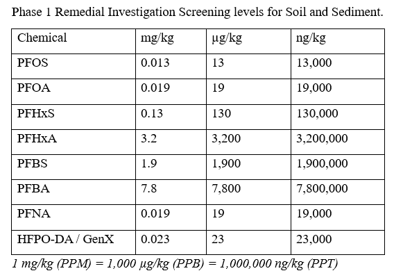
Phase 1 Remedial Investigation Screening levels for Soil and Sediment.
This is dangerously high! Why should we allow the polluter, in this case, the military, to determine cleanup standards? Let’s examine these outrageous standards before viewing more responsible Danish standards.
Denmark’s PFAS framework has been criticized by Danish scientists who concluded that PFAS national thresholds might not be sufficiently health-protective [17]. See below.
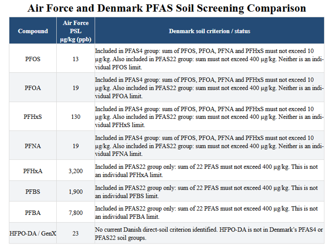
How to read the Denmark column. A single-compound concentration above a group criterion necessarily makes that group exceed the criterion, but a result below it does not establish compliance because the other group members must also be counted.
Let’s compare the 13 ug/kg (ppb) standard for PFOS to the German eluate method to ascertain potential impacts on groundwater. The German eluate method evaluates soil contamination by measuring how much of a pollutant will actually wash out into groundwater during rain events, rather than measuring the total mass bound to dry soil but really doesn’t tell us much.
In the German laboratory process, 2 liters of water is mixed and agitated with a kilogram of dry soil, creating a 2:1 liquid-to-solid ratio. The mixture is filtered to separate the solid particles from the liquid. The resulting fluid—the eluate—is then analyzed for PFAS. Under Germany's federal soil regulations, the screening level for PFOS in this eluate liquid is 0.1 µg/L (100 parts per trillion) [14].
An Australian laboratory study provides a closely comparable example. Soil removed from a fire-station area contained 2,200 µg/kg of PFOS, nearly identical to the 2,100 µg/kg measured in soil at Travis Fire Station 2. In a 24-hour batch-leaching test using 20 parts water to one part soil, that Australian soil released 90 µg/L—90,000 ppt—of PFOS into the test water [15]. Travis soil has not undergone the same test, so 90,000 ppt cannot be presented as a measured or predicted Travis-water concentration. It demonstrates, however, that PFOS-contaminated fire-station soil at this concentration can release very large quantities of PFOS under controlled water-contact conditions.
Canada’s PFOS soil guideline for agricultural/residential/parkland use is 10 µg/kg, and Australia’s residential-with-garden investigation level is 10 µg/kg for PFOS + PFHxS combined. [16] The Travis PFOS result is 210 times the Canadian and Australian benchmark. Travis failed to report PFHxS in soil
The principal concern is not that this soil automatically makes nearby people ill. It is that it is a perpetual source zone. Rain can dissolve and carry PFAS downward toward groundwater that may flow toward the planned city’s center. Rainfall runoff can move contaminated particles and dissolved PFAS to ditches, streams, wetlands, and ultimately fish, wildlife, the air, and people.
It is like a giant carcinogenic, subterranean sponge that squeezes out toxins in perpetuity.
The Pentagon’s screening-level history
In 2019, the Pentagon used 400 ppt as the screening level for the combined concentration of PFOS and PFOA. That was ten times the then-proposed EPA screening value of 40 ppt.
Although EPA’s enforceable drinking-water Maximum Contaminant Level is 4 ppt for PFOA and 4 ppt for PFOS, the Pentagon’s current policy generally does not prioritize interim action at contaminated private wells until either compound reaches 12 ppt—three times the federal standard. The result is a troubling regulatory gap: a private well may contain PFOA or PFOS above EPA’s 4-ppt drinking-water standard yet remain below DoD’s threshold for prompt bottled water, treatment, or another interim remedy.
Today’s Air Force provisional screening levels in groundwater produce a strikingly uneven picture: 4 ppt for PFOS and PFOA, 10 ppt for PFHxS, but 600 ppt for PFBS, 990 ppt for PFHxA, and 1,800 ppt for PFBA [16]. It would be instructive to review the science behind each determination.
Exhibit 1-6 from the Travis PFAS Remedial Investigation has been amended below to provide more context to the shifting regulatory terrain. Relatively responsible Danish standards have been used to provide much needed context.
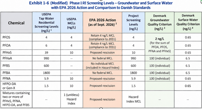
“100 (individual)” refers to Denmark’s 100 ng/L groundwater criterion for each PFAS in a specified list of 22: PFBA, PFPeA, PFHxA, PFHpA, PFOA, PFNA, PFDA, PFUnDA, PFDoDA, PFTrDA, PFBS, PFPS, PFHxS, PFHpS, PFOS, PFNS, PFDS, PFUnS, PFDoS, PFTrS, PFOSA, and 6:2 FTS. The sum all 22 may also not exceed 100 ng/L [17].
DOD plays down risk of PFAS
California’s official Proposition 65 fact sheets say both PFOA and PFOS cause cancer. [28,29]
Meanwhile, the Pentagon is obfuscating the truth. Read through their brief PFAS 101 overview. Its public language understates the relevant science by describing cancer only as a possible consequence of “high levels” and emphasizing that research is evolving. They focus on drinking water while failing to mention groundwater, stormwater, surface water, sediment, dust, fish, and food-chain transfer [18].
The DOD assures the public that treated drinking water is safe, and it typically is. But there are so many other pathways to human ingestion! At Travis AFB, the Phase I RI specifically recognizes that existing groundwater-treatment systems may not fully remove PFAS and recommends evaluating their effluent. That is an unresolved issue.
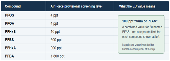
Air Force Groundwater Screening Limits compared to EU Standards
The European Union has established a Groundwater Directive that establishes a 100-ppt groundwater quality standard for the sum of 20 PFAS compounds. [19]
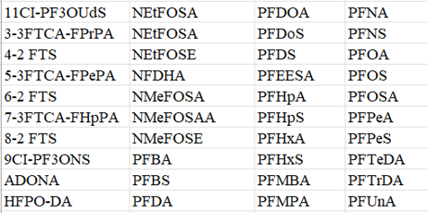
40 PFAS compounds reported by EPA Method 1633
The PFAS sampling protocol at Travis mandates testing for 40 PFAS compounds [37] using EPA Method 1633. The Air Force has likely withheld results on 32 compounds [20].
The San Francisco Bay Regional Water Quality Control Board uses groundwater screening levels of 1.7 ppt for PFOS and 0.54 ppt for PFOA, far below the 4-ppt figures used by the DOD. These are not enforceable cleanup standards, but they show that government agencies can select substantially more protective screening levels [21].
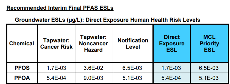
San Francisco Bay Regional Water Quality Control Board screening levels
They don’t publish these things for public consumption. 1.7E-03 µg/L = 1.7 ppt; 5.4E-04 µg/L = 0.54 ppt.

Comparing California and Air Force Groundwater Screening levels
The higher screening levels for various PFAS compounds deserve scrutiny because many have been detected in fish in many thousands of parts per trillion and they are known to adversely impact human health. PFOS is known to aggressively bioaccumulate in fish more than any other PFAS compound. For instance, Michigan reported 9,580,000 ppt of PFOS in a fish sampled from Clark’s Marsh, just south of the former Wurtsmith Air Force Base.
San Francisco Bay PFAS Environmental Screening Levels, (ESLs) compared to Travis AFB Project Screening Levels, (PSLs)
ESLs are risk-based guidelines developed by the San Francisco Bay Regional Water Quality Control Board for assessing contaminated commercial and residential properties.
The following comparison illustrates how sharply screening values can differ among agencies and exposure scenarios. These figures are screening tools rather than enforceable groundwater-cleanup standards. We have already compared the Tavis PSL’s to the EU standards.
For PFOS and PFOA, the summary values in the San Francisco Bay ESL’s are driven by the seafood-ingestion human-health pathway.
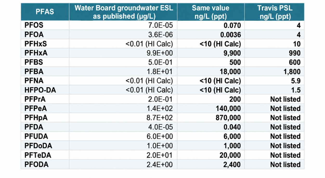
Comparison of San Francisco Bay and Travis AFB PFAS Screening Levels
Scientific-notation values should be accompanied by recognizable parts-per-trillion values. I have added those above.
For PFNA, PFHxS, and HPFO-DA, the Water Board gives ‘<0.01 (HI Calc)’ rather than a stand-alone groundwater number.
Each chemical (PFNA, PFHxS, and HFPO-DA) has a 10-ppt quota limit, while PFBS has a 2,000-ppt quota limit. Every measured concentration uses up a percentage of its specific quota. The Water Board adds these percentages together. The screening threshold is met when the combined total reaches 100%. This is unnecessary and confusing.
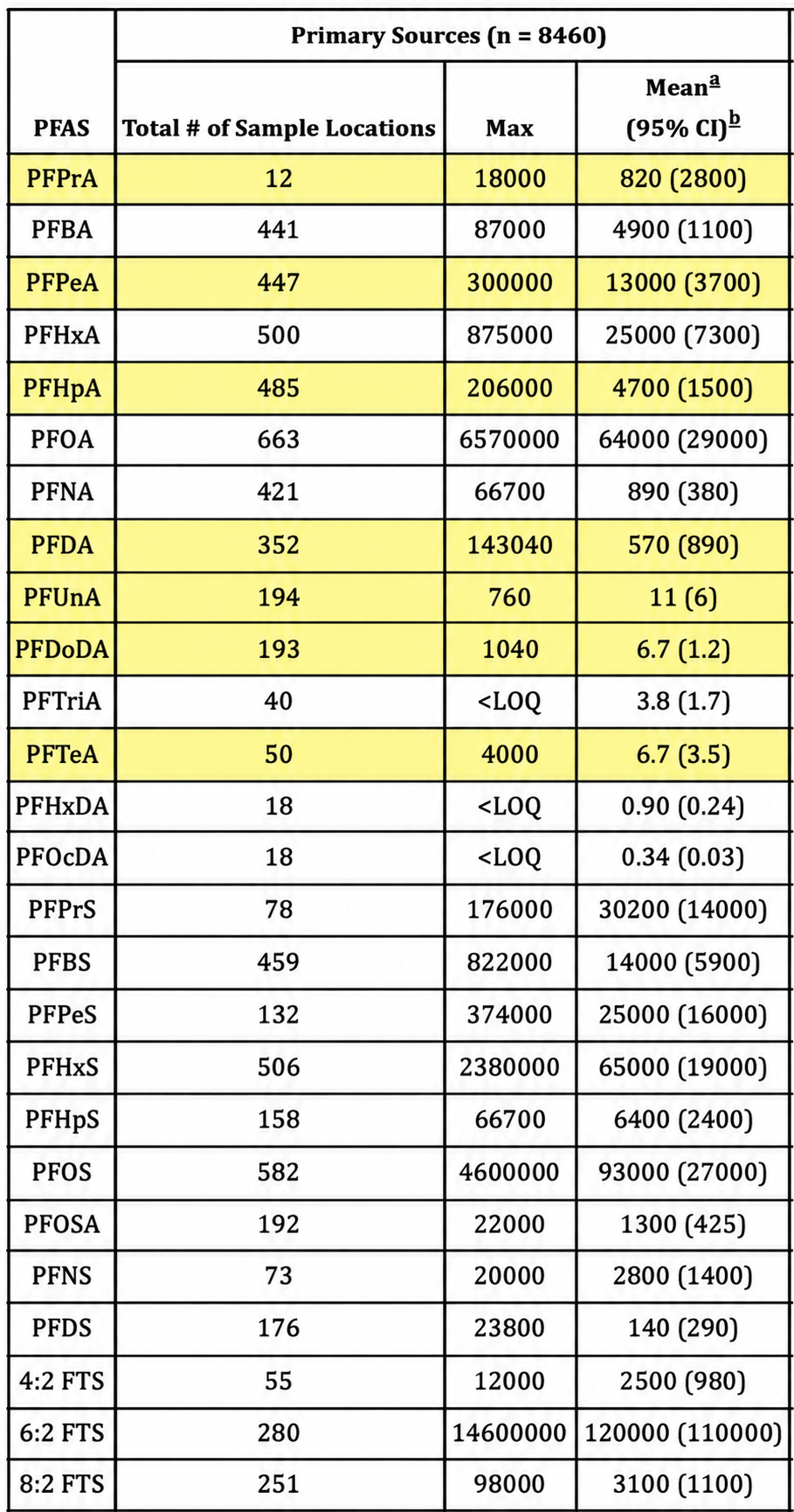
The highlighted rows show seven PFAS Compounds that are monitored by the state of California but ignored by the Air Force. PFUnA is listed by the Water Board as PFUDA and PFTeA is listed as PFTeDA.
The Air Force’s Travis PFAS investigation has emphasized a limited set of compounds and project screening levels. California’s Environmental Screening Level tables, however, include PFPrA, PFPeA, PFHpA, PFDA, PFUDA, PFDoDA, PFTeDA, and PFODA [21, 22].
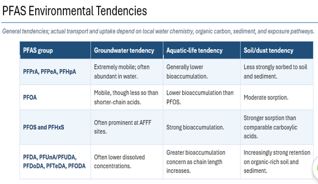
Several of these acids have been reported at substantial concentrations in groundwater elsewhere, while the longer-chain acids are documented in fish and shellfish. Without routine analysis and reporting for the full California analyte set, the Travis investigation cannot establish whether these compounds are absent from groundwater, surface water, sediment, or the food web.
The Environmental Impact Report, Water Supply, and the Unresolved PFAS Threat
As of early October, 2026, Suisun City’s official project page contains the Notice of Preparation and the project application materials, but it does not list or link to a Draft Environmental Impact Report [23].
The most recent publicly reported estimate was that the Draft EIR would not be released before fall 2026 [2]. An earlier prediction by California Forever’s CEO that the report would appear in early 2026 did not materialize. No firm publication date appears to have been announced.
At this point, there has been no mention of the threat posed by PFAS from Travis AFB in any official, NGO, or press reports.
Suisun City, not the Suisun-Solano Water Authority, is the lead agency responsible for preparing and circulating the Draft EIR under the California Environmental Quality Act. California Forever/Flannery Associates is the project applicant. The Suisun-Solano Water Authority may have an important role in evaluating water-service capacity, infrastructure, and supply.
The status can be followed on the city’s Expansion Project application and environmental-review page.
Why the EIR is crucial
The EIR will provide the first comprehensive public evaluation of whether the proposed development can proceed without causing unacceptable environmental consequences. It is expected to describe existing groundwater, surface-water, drainage, and water-quality conditions; quantify water demand during construction and operation; and identify the proposed sources of potable, nonpotable, and recycled water. It will also evaluate potential effects on groundwater levels, neighboring wells, connected surface waters, and Suisun Marsh, while examining the necessary wastewater, recycled-water, storage, conveyance, and treatment infrastructure. Critically, the EIR should evaluate water-quality hazards, including PFAS contamination associated with Travis Air Force Base, and identify appropriate mitigation measures and reasonable project alternatives.
This matters because general assurances that water “will be available” are not a substitute for a verified water budget, reliable-yield analysis, water-quality investigation, or groundwater model. As Solano County Resource Management Director James Bezek stated, “Vague statements like ‘water will be available’ are insufficient.”
A detailed discussion of the unresolved questions (although not PFAS) appears in Bay Nature’s March 2026 article, “A Hunger for Answers on California Forever’s Environmental Impacts” [2].
The uncertainty surrounding water for 400,000 people
The proposed first phase would accommodate as many as 150,000 residents and, according to California Forever’s plan, initially rely on groundwater and recycled water. The broader development vision has contemplated an eventual population of approximately 400,000.
The EIR must evaluate the water required for the currently proposed project while also considering the reasonably foreseeable cumulative effects of the larger buildout.
Significant questions remain because southeastern Solano County’s groundwater has historically received relatively little municipal use or systematic water-quality monitoring. Before the adequacy of the proposed supply can be determined, the EIR should disclose the projected annual, average-day, and peak-day water demands for every phase of development. It should identify the locations, depths, capacities, and capture zones of the proposed wells and determine whether groundwater withdrawals would be sustainable under normal, drought, and climate-stressed conditions.
The analysis should examine possible effects on agricultural, domestic, and municipal wells outside the project area, as well as the hydrologic connections among groundwater, Union Creek, the Montezuma Hills drainage system, and Suisun Marsh. It should thoroughly characterize existing groundwater quality, including PFAS, salts, nitrate, metals, and other contaminants.
The EIR should also identify necessary water-treatment requirements and explain how PFAS-contaminated treatment residuals would be managed. It should quantify how much recycled water would actually be available during the project’s early development, seasonal fluctuations, and drought conditions. For later phases, the EIR should identify a secured and reliable long-term water supply rather than assume that an additional source will eventually be found.
Recycled water is an important resource. It generally depends on water first being supplied to the community, used, collected as wastewater, treated, and redistributed. The devil is in the details because traditional wastewater treatment does not address PFAS contamination, which is likely to be abundant.
Consequently, new development cannot rely on recycled-water production to solve its initial supply requirements without addressing the exorbitantly expensive PFAS issue.
For a population approaching 400,000, even a relatively small error in projected per-capita demand, groundwater recharge, drought reliability, or treatment capacity could translate into a very large regional supply deficit. The scale makes uncertainty itself environmentally significant.
PFAS from Travis Air Force Base
PFAS contamination associated with Travis Air Force Base is potentially a decisive water-quality issue for the EIR.
Investigations at Travis have documented PFAS in multiple environmental media, including groundwater, soil, surface water, sediment, and pore water. Particularly high pore-water concentrations demonstrate that PFAS remains mobile within the unsaturated soil and can be expected to continue leaching toward groundwater. Other portions of the base are known to have still higher groundwater concentrations, while the full horizontal and vertical extent of contamination has not been established.
Careful investigation is warranted because Travis Air Force Base is a major, incompletely delineated PFAS source with documented historical releases affecting soil, pore water, groundwater, and surface-water pathways. At the same time, the proposed development may depend on groundwater that has not been extensively developed or systematically monitored. Large-scale pumping could alter groundwater gradients and contaminant movement, potentially creating long-term treatment, monitoring, waste-disposal, and replacement-water costs.
The EIR therefore should not treat PFAS merely as a generic hazardous-materials issue. It should evaluate PFAS in the context of groundwater supply and quality, regional hydrology, cumulative environmental effects, and the feasibility and cost of providing safe public water.
At a minimum, that evaluation should include current PFAS sampling of proposed well fields, delineation of Travis-area plumes, groundwater-flow and pumping simulations, analysis of capture zones under full buildout, monitoring triggers, treatment feasibility, treatment-residual disposal, and clearly assigned financial responsibility if contamination affects the project’s supply.
Conclusion
The Draft EIR will be the critical test of whether the development’s water claims are supported by measurable evidence. Until the groundwater resource, regional hydrologic effects, and PFAS risks are characterized, it would be premature to conclude that a reliable and safe water supply exists for either the first 150,000 residents or the broader vision of 400,000 people.
The central question is not simply whether water can be pumped. It is whether sufficient water can be supplied safely, sustainably, and affordably—without spreading contamination or transferring unresolved environmental liabilities to future residents and public agencies.
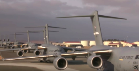
Travis AFB, CA - Mass launch of 22 Lockheed
C5-M Galaxy & Boeing C-17 Globemaster III
Air Military Transport Aircraft - US Air Force Photo
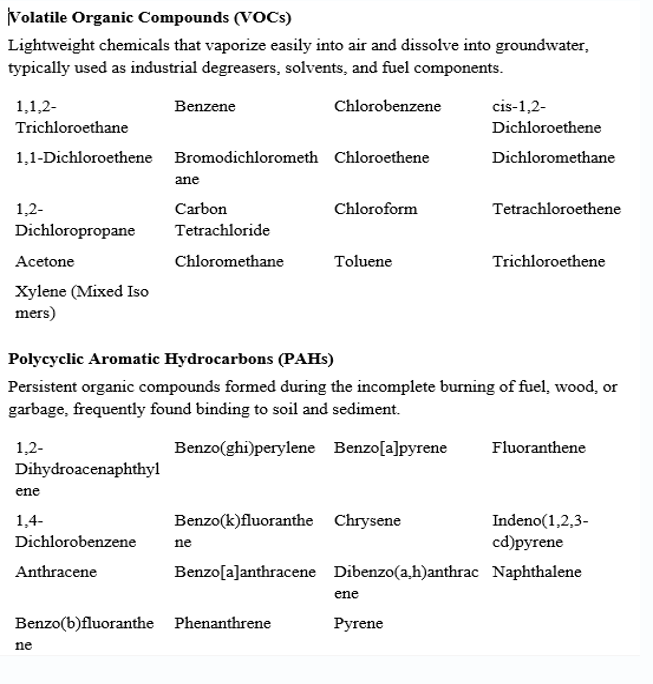
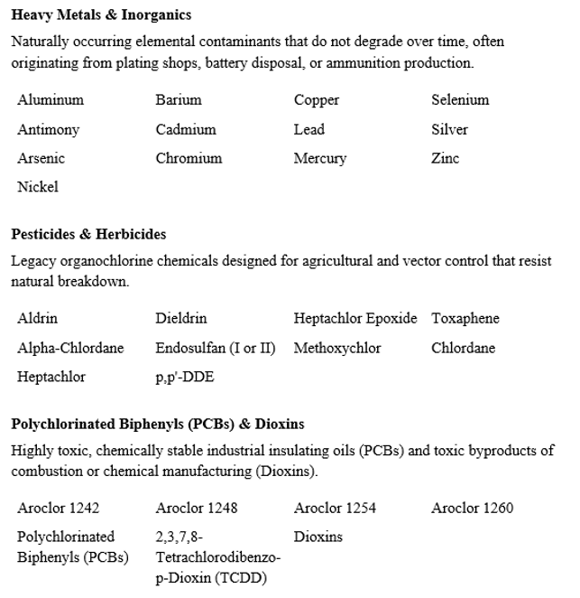
Below is a list of contaminants found in the water and soil at Travis Air Force Base. Many sites where these toxins were documented have been declared “clean” by the DOD but are still not safe. ProPublica warns that Travis Air Force Base is safe only with dig permit restrictions on groundwater and restrictions on land use [24].
ProPublica obtained this data by filing extensive Freedom of Information Act (FOIA) requests. This source of information has largely “fizzled into nothingness” under the Trump Administration.
The following list of contaminants originates from the Pentagon's internal Defense Environmental Restoration Program (DERP). Journalists at ProPublica extracted the raw chemical inventories from these federal records to build their investigative news application, Bombs in Your Backyard, which maps out more than 40,000 hazardous military sites. Many communities are threatened.
Travis AFB traces back to Fairfield Air Force Station, an Atomic Energy Commission facility established around 1940 that stored and maintained nuclear weapons before being absorbed into Travis.
ProPublica documented the presence of Uranium 234 and Uranium 235 on the base. [24]. The half-life of Uranium 235 is about 703.8 million years. The half-life of Uranium-234 is about 245,500 years. Both are alpha-emitting radionuclides. The very different half-lives mean U-234 has a much higher specific activity—radioactivity per unit mass—than U-235.
The two isotopes have the same basic type of radiological hazard: both emit alpha particles. The important difference is the rate of decay. For the same mass of uranium, U-234 undergoes roughly 2,900 times more radioactive decay than U-235 because its half-life is so much shorter. If the same mass of each isotope entered the body in the same chemical form, U-234 would therefore generally deliver a much larger internal radiation dose [25].
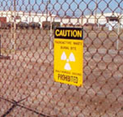
Site RW013, formally the Low-Level Radioactive Burial Site #2, was a fenced, backfilled trench at Travis Air Force Base that received waste from nuclear-material maintenance activities conducted in Building 903. RW013 was identified as the only site on the base with elevated radioactive readings and a potential human-health risk.
“Low-level radioactive waste” is a regulatory or administrative category, not a finding that the material was harmless or that the burial site posed only a trivial risk.
Between October 2002 and February 2003, the Air Force excavated the buried waste and surrounding contaminated soil and shipped it to a licensed low-level radioactive waste repository in Utah. [24]. Confirmatory sampling was reported to meet standards for unrestricted, residential-level use, and the site was formally closed out in 2004.
The problem is that the final determination was made by the Air Force itself. After all, there is no evidence of an EPA-led or as California DTSC radiological survey specific to RW013, nor any published isotope inventory tied to the closeout.
For a site handling nuclear-weapons-maintenance waste, this is a real gap: self-certification by the same agency responsible for the original contamination is a structurally weak form of assurance, however competently the work might have been done. An independent radiological survey — ideally by a party with no institutional stake in the original cleanup's success, would close a serious documentation gap.
References
[1] Garamendi, John. “Garamendi Testifies Before California Legislature Senate Committee on Agriculture.” Congressman John Garamendi, 5 Sept. 2023, garamendi.house.gov/2023/09/05/media-press-releases-garamendi-testifies-california-legislature-senate-committee-agriculture/.
[2] Gupta, Tanvi Dutta. “A Hunger for Answers on California Forever's Environmental Impacts.” Bay Nature, 4 Mar. 2026, baynature.org/2026/03/04/science-nature/a-hunger-for-answers-on-california-forevers-environmental-impacts/.
[3] “Our Main Concerns.” Solano Together, 2026, www.solanotogether.org/our-main-concerns. Accessed 26 Sept. 2026.
[4] Sustainment and Restoration Services, LLC. Phase I Remedial Investigation of Aqueous Film Forming Foam Areas at Travis AFB, Travis Air Force Base, Solano County, California. Final Report, Prepared for Air Force Civil Engineer Center and U.S. Army Corps of Engineers, Albuquerque District, Jan. 2026. U.S. Army Corps of Engineers Contract No. W912PP20C0014.
[5] “Drinking Water Quality Reports.” City of Suisun City, Finance Department, 2026, www.suisun.com/Departments/Finance-Department/Drinking-Water-Quality-Reports.
[6] California Forever. Water Supply and Infrastructure Assessment: The Suisun Expansion Plan. City of Suisun City Development Services, June 2024. Municipal Project Repository Submission.
[7] United States, Department of Defense. “CERCLA Phases and Milestones.” Defense Environmental Restoration Program Annual Report to Congress, Office of the Assistant Secretary of Defense for Energy, Installations, and Environment, Mar. 2016.
[8] Veltman, Chloe. “California Forever Releases Water Plan, but There Are Still Some Questions.” KQED, 18 June 2024, www.kqed.org/news/11991234/california-forever-releases-water-plan-but-there-are-still-some-questions.
[9] East Solano Homes, Jobs, and Clean Energy Initiative. 14 Feb. 2024, solano.californiaforever.com/wp-content/uploads/2024/07/2024-02-14_Initiative.pdf Submitted to the Solano County Registrar of Voters.
[10] California Department of Fish and Wildlife. “Hill Slough Wildlife Area.” CDFW Land Profiles, State of California, 2026, wildlife.ca.gov/Lands/Places-to-Visit/Hill-Slough-WA. Accessed 26 Sept. 2026.
[11] HydroGeoLogic, Inc. (HGL). Revised Final Preliminary Assessment Report for Perfluorinated Compounds Areawide at Travis Air Force Base, California. Prepared for Air Force Civil Engineer Center and U.S. Army Corps of Engineers, 26 May 2015. Air Force Civil Engineer Center Administrative Record.
[12] Oneida Total Integrated Enterprises, LLC. Final Site Inspection for Aqueous Film Forming Foam Areas at Travis Air Force Base, California. Prepared for Air Force Civil Engineer Center and U.S. Army Corps of Engineers, Tulsa District, July 2018. U.S. Army Corps of Engineers Contract No. W912BV-15-C-0082.
[13] Sun, Jennifer, et al. Contaminant Concentrations in Sport Fish from San Francisco Bay: 2014. SFEI Contribution #806, San Francisco Estuary Institute, June 2017.
[14] Germany, Federal Ministry for the Environment, Nature Conservation, Nuclear Safety and Consumer Protection (BMUV). Federal Soil Protection and Contaminated Sites Ordinance (BBodSchV). As amended by the Mantelverordnung, 1 Aug. 2023.
[15] Bräunig, Jennifer, et al. “Leaching and Bioavailability of Selected Perfluoroalkyl Acids (PFAAs) from Soil Contaminated by Firefighting Activities.” Science of the Total Environment, vol. 646, 2019, pp. 471–79.
[16] Canadian Council of Ministers of the Environment. Canadian Soil and Groundwater Quality Guidelines for the Protection of Environmental and Human Health: Perfluorooctane Sulfonate (PFOS). CCME, 2021.
[17] Denmark, Miljøstyrelsen (Danish Environmental Protection Agency). Reviderede kvalitetskriterier for PFAS i jord, grundvand, drikkevand og overfladevand [Revised Quality Criteria for PFAS in Soil, Groundwater, Drinking Water, and Surface Water]. Ministry of Environment, June 2021.
[18] United States, Department of Defense. “PFAS 101: PFAS Overview.” Office of the Assistant Secretary of Defense for Energy, Installations, and Environment, 2026.
[19] Council of the European Union. “Safeguarding Water Quality: Council Signs off on Stricter Protection Rules for Surface Water and Groundwater.” Consilium, 17 Feb. 2026.
[20] Cash, Cynthia, Rick Wice, and Megan Duley. Air Force PFAS Fingerprint and Background Studies. Department of the Air Force, 26 June 2024. Joint Engineer Training Symposium, Society of American Military Engineers, Savannah Post.
[21] California Regional Water Quality Control Board, San Francisco Bay Region. Transmittal of Interim Final Environmental Screening Levels (ESLs) for Two Per- and Polyfluoroalkyl Substances (PFAS): Perfluorooctane Sulfonate (PFOS) and Perfluorooctanoate (PFOA). State of California, 27 May 2020.
[22] Johnson, G. R., et al. “Global Distributions, Source Attribution, and Polyfluoroalkyl Substances in Groundwater.” Science of the Total Environment, vol. 838, pt. 4, 15 Sept. 2022, article 156540.
[23] “Suisun Expansion Project Application and Documents.” City of Suisun City, 2026, www.suisun.com/Departments/Development-Services/Suisun-Expansion-Project-Application-and-Documents . Accessed 26 Sept. 2026.
[24] “Bombs in Your Backyard: Travis Air Force Base.” ProPublica, 5 Dec. 2017, projects.propublica.org/bombs/installation/CA9571824575005700.
[25] United States, Agency for Toxic Substances and Disease Registry. Toxicological Profile for Uranium. U.S. Department of Health and Human Services, National Center for Environmental Health, Feb. 2013.
[26] Water Test Kit for PFAS. Cyclopure, 2026, cyclopure.com. Accessed 26 Sept. 2026. https://cyclopure.com/products/water-test-kit
[27] Wood-Schultz, M., et al. “Characterizing Volatile Emissions and Combustion By-Products from Aqueous Film-Forming Foams Using Online Chemical Ionization Mass Spectrometry.” Environmental Science & Technology, vol. 58, no. 8, 2024, pp. 3812–3822. PubMed Central, www.ncbi.nlm.nih.gov/pmc/articles/PMC10985785/
[28] California Environmental Protection Agency, Office of Environmental Health Hazard Assessment. “PFOA (Perfluorooctanoic Acid).” Proposition 65 Warnings Website, Dec. 2022, www.p65warnings.ca.gov/fact-sheets/pfoa-perfluorooctanoic-acid. https://www.p65warnings.ca.gov/fact-sheets/pfoa-perfluorooctanoic-acid
[29] California Environmental Protection Agency, Office of Environmental Health Hazard Assessment. “PFOS (Perfluorooctane Sulfonate or Perfluorooctane Sulfonic Acid).” Proposition 65 Warnings Website, Dec. 2022, www.p65warnings.ca.gov/fact-sheets/pfos-perfluorooctane-sulfonate-or-perfluorooctane-sulfonic-acid.
[30] Solano Together. 2026, www.solanotogether.org. Accessed 28 Sept. 2026. https://www.solanotogether.org/
[31] United States, Department of the Air Force. Restoration Program Manager's (RPM) Meeting Minutes and Handouts Draft. Air Force Civil Engineer Center (AFCEC), Installation Support Section, Jan. 2021, www.travis.af.mil/Portals/30/2021_01_2021_RPM_Draft-includes_Handouts_R1%20%282%29.pdf. Travis Air Force Base Environmental Restoration Program Administrative Record, p. 102
[32] Constantinescu, Adriana. “Completion of Drinking Water Treatment Systems for PFAS South of Travis AFB, Solano County.” Executive Officer’s Report, California Regional Water Quality Control Board, San Francisco Bay Region, 7 July 2021, p. 4, www.waterboards.ca.gov/sanfranciscobay/board_info/agendas/2021/July/4_ssr.pdf.
[33] United States, Department of the Air Force. Final Restoration Program Manager's (RPM) Meeting Minutes with Attachments. Air Force Civil Engineer Center (AFCEC), Jan. 2023, www.travis.af.mil/Portals/30/2023_01-Final_Travis_RPM_Meeting_Minutes_Jan2023_with_attachments%20%282%29.pdf Travis Air Force Base Environmental Restoration Program Administrative Record.
[34] Travis AFB PFAS Remedial Investigation Data Gaps Phase 1A.” Abierto, 16 Sept. 2026, abierto.us/opportunities/w912pp26ca012. U.S. Department of the Army Contract No. W912PP26CA012 Awarded to General Mechanical Corporation.
[35] “Water Delivery.” Orange County Water District, 2026, www.ocwd.com/water-delivery/. Accessed 28 Sept. 2026
[36] United States, Agency for Toxic Substances and Disease Registry. Martinsburg, Berkeley County, West Virginia: Per- and Polyfluoroalkyl Substances (PFAS) Exposure Assessment Report. National Center for Environmental Health, 20 Jan. 2022, atsdr.cdc.gov/pfas/docs/ATSDR-PFAS-BerkeleyCounty-Report-508.pdf.
[37] United States, Environmental Protection Agency. “CWA Analytical Methods for Per- and Polyfluoroalkyl Substances (PFAS).” US EPA, 25 Feb. 2026, www.epa.gov/cwa-methods/cwa-analytical-methods-and-polyfluorinated-alkyl-substances-pfas. Accessed 28 Sept. 2026